


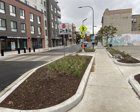
Photos show views of the Evanston, Ill., Main Street Improvement Project as well as improved soil systems (above) and ADA barriers along Evanston Main Street (below).
The summer of 2025 was characterized by an abnormally high number of extreme precipitation events, dowsing regions across the country with torrential rainfalls and leading some to deem 2025 the “year of the flood.” By late July, the National Weather Service had issued more than 3,600 flash-flood warnings, a number closer to the standard yearly average, and some areas east of the Rockies received at least 50 percent more precipitation than normal during the three-month period spanning from April to July.
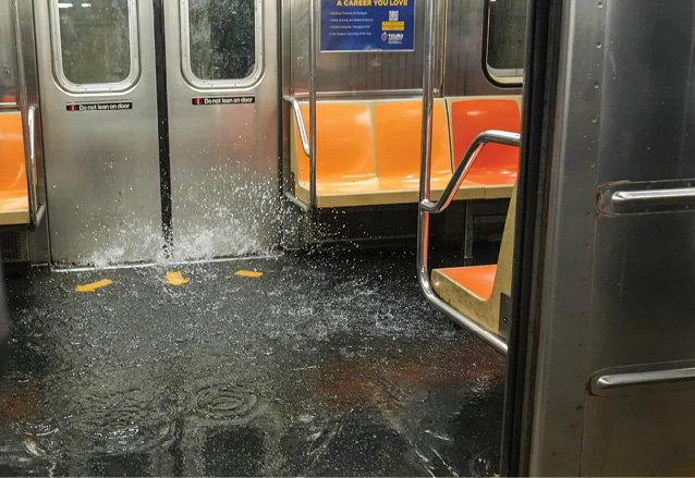
Beyond paralyzing communities and causing irreparable damage in rural areas, the increase in flash floods also placed a spotlight on the vulnerabilities in transportation infrastructure and the implications this has on health, safety and equity. On July 14, 2025, crushing rains in the Northeast caused severe flash flooding in New York and New Jersey. Images circulated of water gushing into New York City (NYC) subway stations, shocking commuters and paralyzing a transit system that 3.6 million individuals rely on daily.
The events of the summer underscore a pressing and complex challenge facing engineering and regulatory professionals: the growing urgency for resilient infrastructure in mitigating flood risks in a warming climate. Addressing such a challenge not only requires innovative thinking and technical expertise, but also the willingness to explore beyond traditional approaches. These events aren’t isolated; they represent a new normal that will shape how we plan, fund and manage infrastructure nationwide.
Keys to the Future
While the path toward embracing a resilience-centered approach may still be emerging, there are various key aspects to consider when discussing the future of transportation infrastructure and climate adaptation.
First, and maybe most crucially, is the need for a comprehensive resilience-assessment framework. While it’s true that we can’t predict all threats, we can work to understand how a system operates under extreme stress or behaves during disruption. Significant research has contributed to our understanding of the benefits of resilience assessments vs. a more-common risk assessment; however, the challenge comes in implementation.
Resilience planning in the United States isn’t unprecedented, but the scale, urgency and coordination it now demands are. While there’s growing federal guidance and funding to advocate for climate resilience, the real challenge lies in achieving alignment at the state, regional and local levels where decisions and policy are made. Most metropolitan areas have some form of resilience or climate-adaptation strategy, yet these vary widely depending on geography, governance structures and the type of stresses each region faces.
As weather events grow more frequent and severe, gaps in coordination and preparedness are being exposed, revealing that a national framework alone can’t ensure readiness. The next frontier of resilience planning depends on how effectively communities can translate broad federal policy into localized action: integrating data, infrastructure priorities and equality considerations in real time to make decisions that reflect on-the-ground realities.
One pathway for achieving this alignment is through empowered local and regional agencies—entities that understand the context, assets, vulnerabilities and lived experience of their communities. When equipped with good data and decision-making flexibility, these agencies can embed resilience directly into project planning and delivery instead of treating it as a separate objective.
A Better Main Street
The Evanston Main Street Improvements project is an example of this approach in action, showcasing how local-led initiatives can transform federal resilience goals into practical, community-centered outcomes.
To address climate impacts such as increased storm intensity and surface flooding, Evanston, Ill., implemented permeable pavers along parking lanes. The pavers reduce stormwater runoff, which lowers the risk of flooding and decreases pressure on aging storm-sewer systems. The project also preserved and relocated mature Honey Locust trees and installed continuous tree-pit soil systems to strengthen long-term tree health, demonstrating how climate adaptation can be integrated with urban placemaking and ecological stewardship.
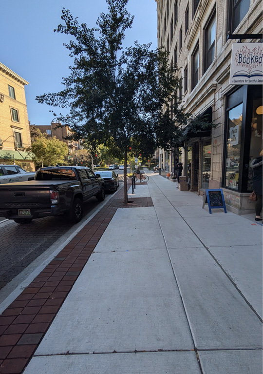
Permeable pavers were installed along parking lanes on Evanston’s Main Street to lower risk of flooding
In this project, resilience was also equally tied to social and mobility equity. The corridor included areas with significant Americans with Disabilities Act (ADA) barriers such as uneven pavers, narrow sidewalks and grade challenges near Park School (a public therapeutic day program). Evanston addressed these through ADA-compliant sidewalks, curb bump-outs, raised crossings and improved pedestrian visibility features, ensuring safety for individuals with mobility challenges while also slowing vehicle speeds and mitigating crash risk.
Other improvements, including expanded sidewalks, new ramps and safer building-access points, illustrate how resilience extends into economic sustainability by strengthening local businesses, improving walkability and creating public spaces built for long-term adaptability and community use. The project’s extensive stakeholder engagement, including multiple public meetings and advisory committees, ensured decisions reflected community priorities and supported implementation with minimal disruption.
Taken together, these interventions demonstrate what it looks like when a community moves beyond compliance-driven resilience thinking and toward operationalizing resilience, integrating green infrastructure, safety, accessibility and climate-conscious materials into core capital programs. Evanston’s approach shows that resilience becomes most effective not through sweeping national mandates but through localized, data-driven, community-responsive decisions that elevate safety, sustainability and equity concurrently.

Photos from NYC show a flooded subway entrance (top) as well as subways flooded during heavy rainfall in July 2025 (bottom) (David Dee Delgado/Getty Image & Selcuk Acar, Anadolua/Getty Images)
A Call to Engineers
As climate impacts intensify, the engineering community will increasingly be called upon not only to design infrastructure that endures, but also to help shape the data frameworks, funding structures and partnerships that make resilience achievable. Across the country, agencies are beginning to reevaluate how they define design-storm events and how infrastructure should be planned, sized and maintained to accommodate a broader range of storm intensities and future uncertainty.
This shift reflects a growing recognition that traditional design assumptions based on historic precipitation data no longer hold true in a changing climate. Federal and state transportation agencies, including Federal Highway Administration (FHWA) and several state DOTs, now are exploring climate-informed design standards and risk-based approaches to update drainage criteria, culvert sizing and pavement-management practices. The future of transportation infrastructure depends on our ability to connect these layers—policy, design and human impact—into a cohesive and adaptable system.
Proactively assessing common situations and implementing protocols based in scenario modeling allows agencies to improve a system’s ability to recover and adapt. For example, FHWA’s resilience analysis tools allow agencies to model asset performance under different climate scenarios, improving decision-making around lifecycle costs and adaptive design. The solution isn’t strictly about adding redundancies but instead to maximize efficiency and resilience through time, creating a dynamic assessment and response framework that balances short-term performance and recovery with long-term adaptability to ensure transportation planning remains responsive and future ready.
No assessment framework is complete without centering equitable solutions. Transportation equity is a critical aspect of modern infrastructure resilience planning to guarantee all individuals and communities have fair access to safe and reliable transportation—something that becomes even more important in times of crisis.
Underserved communities disproportionately face barriers to accessing public transportation. However, these individuals are most likely to rely on this public service during emergencies. In addition, individuals with disabilities or mobility challenges may find it difficult to navigate the conditions caused by extreme weather events.
Place-Based Solutions
Best practices across the country demonstrate that equity and resilience are deeply interconnected, and solutions must reflect each region’s unique climate realities.
For instance, the North Carolina DOT developed a “Community Vulnerability Assessment Tool” that overlays social vulnerability data (e.g., income, race, age, car ownership, disability, etc.) with flood and storm exposure. This allows planners to identify where extreme rainfall and hurricanes are most likely to disrupt mobility for those with the fewest transportation options. By prioritizing upgrades to evacuation routes, drainage systems and transit shelters in these communities, the state ensures that resilience investments reach those most affected by the Southeast’s growing flood and storm intensity.
In NYC, transportation equity has become central to post–Hurricane Sandy adaptation efforts. The city has worked to elevate and floodproof subway entrances in high-risk neighborhoods, enhance ADA-compliant access to evacuation routes, and provide multilingual emergency alerts to ensure all residents can receive and act on real-time information during storm events. These measures directly respond to the region’s increasing exposure to coastal flooding and extreme precipitation, ensuring that residents who depend on public transit aren’t left behind when systems are disrupted.
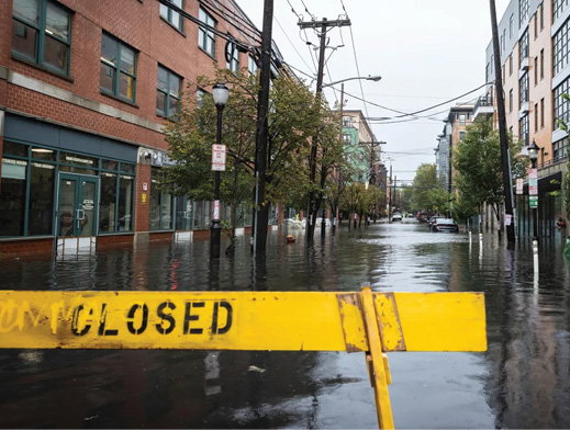
A photo of street closures during 2023 flooding across NYC and New Jersey.
Across the country in Los Angeles, heat—not flooding—drives a different type of resilience challenge. To protect transit-dependent communities facing rising urban temperatures, LA Metro piloted “cool pavement” materials and shade-canopy programs along high-ridership corridors in low-income neighborhoods with limited green space. These projects reduce surface temperatures, improve comfort and safety for riders, and demonstrate how resilience must adapt to local conditions (in this case, chronic heat and air-quality stressors rather than acute flooding).
As another example, the Chicago Metropolitan Agency for Planning (CMAP) integrates equity and resilience through its “Climate Action Plan for the Chicago Region,” which applies equity scoring metrics to prioritize transportation and infrastructure projects that improve access and safety for environmental justice communities most affected by Midwestern flooding, freeze-thaw cycles and heat extremes. By tying equity directly to project selection, CMAP ensures that climate adaptation and social equity advance together across the region’s diverse communities.
These examples illustrate that equitable resilience isn’t a one-size-fits-all concept, where geography fundamentally shapes both the nature of risk and the form resilience must take. Whether coastal flooding, inland storms, extreme heat or freeze-thaw degradation, the climate solutions facing each region demand solutions tailored to local conditions and the people most affected. Embedding equity into resilience planning ensures that infrastructure investments do more than harden systems—they strengthen communities.